
The purpose of the special public interest overlay districts is to protect and enhance certain specific lands, uses and structures which, by virtue of their type or location, have characteristics which are distinct from lands and structures outside such overlay districts. It is the intent of the city commission to permit, insofar as possible, those uses and structures, which would otherwise be permitted, provided that reasonable and necessary conditions are met which ensure the protection and enhancement of said lands, uses and structures. It is the further intent of the city commission to specifically protect and enhance the following:
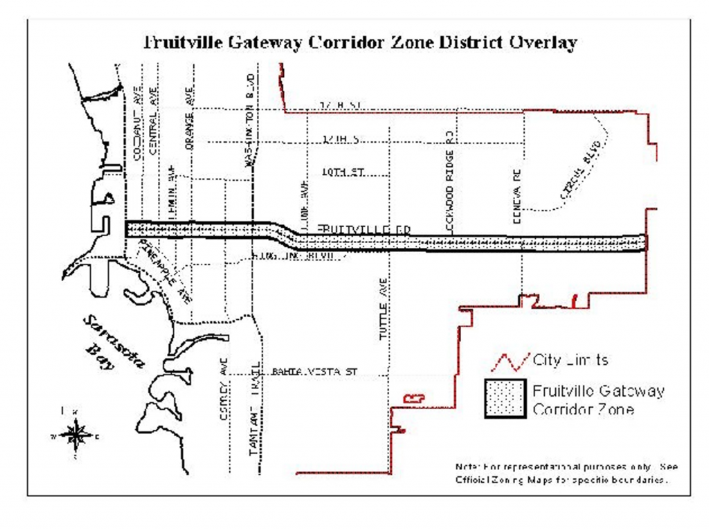
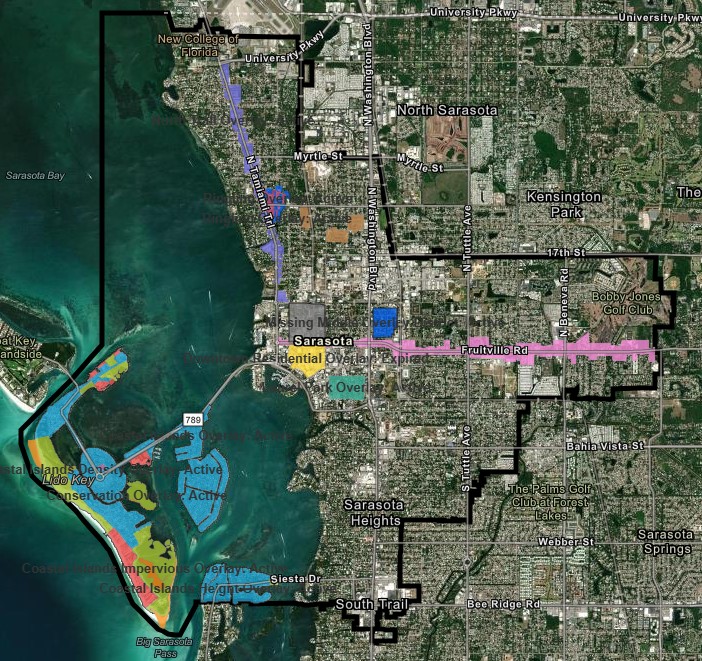
Fruitville Gateway Corridor Overlay District
The Fruitville Gateway Corridor Overlay District (FCOD) is intended to further the purposes set forth in F.S. § 163.3202, implementation of the adopted Sarasota City Plan as amended, and in general to protect the health, safety and general welfare of the public by the prevention or reduction of traffic congestion, avoidance of distracting visual clutter, and preservation of the aesthetic value in the Fruitville Road corridor by:
(1) Creating an enhanced visual eastern gateway to the city.
(2) Encouraging unified signage plans.
(3) Enhancing the appearance and environment of the city.
(Ord. No. 02-4357, 4-29-02; Ord. No. 03-4472, § 8, 6-16-03; Ord. No. 13-5053, § 2(Exh. A), 5-6-13; Ord. No. 13-5055, § 2(Att. 1), 5-6-13)
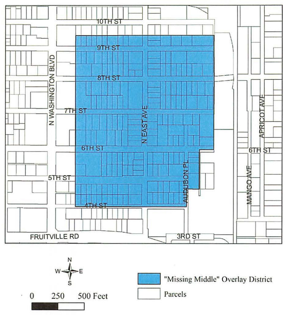
“Missing Middle” Overlay District
The “Missing Middle” Overlay District (MMOD) and the increased residential dwelling unit density allowable within the overlay district is intended to:
(1) Implement the Sarasota City Plan.
(2) Promote higher density residential development and increase availability of attainable housing.
(3) Encourage more people to permanently reside within the boundaries of the MMOD in order to enhance the economic vitality of the surrounding neighborhood and downtown.
(Ord. No. 22-5430, § 2(Exh. A), 12-5-22)
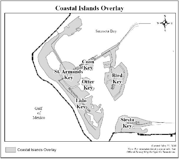
Coastal Islands Overlay District (CIO).
The Coastal Islands Overlay (CIO) is intended to protect the environmentally sensitive and fragile nature of the coastal islands and their evacuation needs. The regulations address the density, intensity and scale of development consistent with the Environmental Protection and Coastal Island chapter of the Sarasota City Plan. The CIO consists of four subdistricts and are mapped separately below:
(1) The Impervious Surface Overlay District (ISOD) is intended to limit increases in impervious surface for new construction.
(2) The Height Overlay District (HOD) is intended to limit increases in the height for new construction.
(3) The Density Overlay District (DOD) is intended to limit increases in residential density for new construction.
(4) The Conservation Overlay District (COD) is intended to protect these generally undeveloped coastal, environmentally sensitive areas, which include beaches, dunes, coastal hammocks, mangrove swamps, tidal islands, tidal marshes and other marine and estuarine habitats.
(Ord. No. 02-4357, 4-29-02; Ord. No. 09-4888, § 2(att. 1), 11-2-09; Ord. No. 13-5055, § 2(Att. 1), 5-6-13; Ord. No. 20-5337, § 2(exh. A), 8-17-21; Ord. No. 22-5404, § 2, 3-7-22)

Ringling Overlay District (ROD).
The Ringling Overlay District (ROD) is intended to provide a means by which the Ringling College of Art and Design (RCAD) may continue to function and grow in a sensitive and planned manner that preserves the integrity and long-term viability of the surrounding neighborhood.
(Ord. No. 07-4770, § 2, 12-17-07; Ord. No. 09-4838, § 2(att. 1), 2-17-09; Ord. No. 21-5342, § 2(Exh. A), 12-7-20)
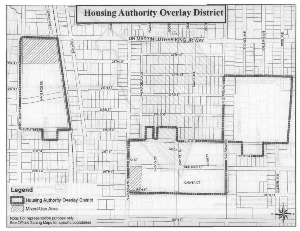
Housing Authority Overlay District (HAOD).
The Housing Authority Overlay District (HAOD) is intended to provide a means by which the housing authority may continue to function and grow in a sensitive and planned manner that preserves the integrity and long-term viability of the surrounding neighborhood.
(Ord. No. 07-4770, § 2, 12-17-07; Ord. No. 13-5041, § 2(att. 1), 3-4-13; Ord. No. 13-5055, § 2(Att. 1), 5-6-13; Ord. No. 18-5234, § 2(Exh. A), 2-5-18; Ord. No. 21-5346, § 2(Exh. A), 5-18-21)
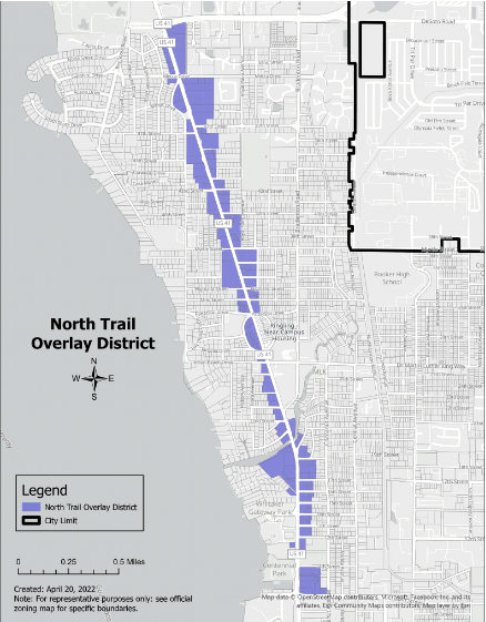
North Trail Overlay District (NTOD).
The character of the North Trail corridor began to change following the completion of Interstate 75 in the early 1980s. What was once a thriving segment of US 41 consisting of many destination businesses slowly began to deteriorate. Since 1989, various studies of the North Trail corridor have been undertaken in an effort to revitalize this part of the city. The studies have provided guidance on how to transform the corridor into a thriving, walkable district that supports local community redevelopment objectives and new urbanism concepts. This community-based vision has continued to evolve through close consultation with the people living and working along the corridor with the ultimate goal of creating sustainable redevelopment with quality buildings and streetscapes that are compatible with adjacent residential neighborhoods. It is a long-term vision that will need to occur in phases over time.
(Ord. No. 08-4799, § 2, 4-28-08; Ord. No. 09-4838, § 2(att. 1), 2-17-09; Ord. No. 09-4888, § 2(att. 1), 11-2-09; Ord. No. 13-5041, § 2(att. 1), 3-4-13; Ord. No. 13-5053, § 2(Exh. A), 5-6-13; Ord. No. 18-5244, § 2(Exh. A), 4-16-18; Ord. No. 19-5300, § 2(Exh. A), 10-7-19; Ord. No. 22-5414, § 2(Exh. A), 5-16-22)
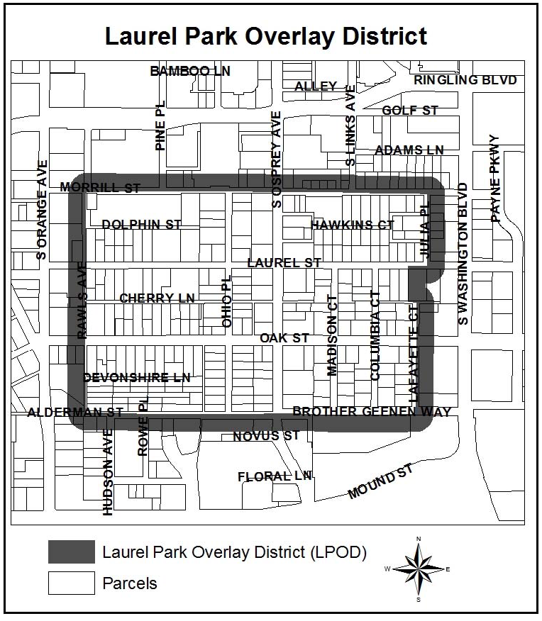
Laurel Park Overlay District (LPOD).
The Laurel Park Overlay District (LPOD) is intended to enhance communication between a developer or landowner and residents within the Laurel Park neighborhood when a building permit or administrative site plan is proposed within the overlay district that meets or exceeds the thresholds of subsection IV-501(c). This section applies to all applications for administrative site plan approval which may be processed in advance of a building permit or in conjunction with a building permit which meet or exceed the thresholds set out in subsection IV-501(c). However, if two community workshops have been held on an administrative site plan application as required by subsections VI-911(c) and (e); then no additional community workshops are required if a subsequent application for a building permit is filed to allow construction in accordance with a previously approved and currently valid site plan.
(Ord. No. 13-5054, § 2(Exh. A), 8-19-13)
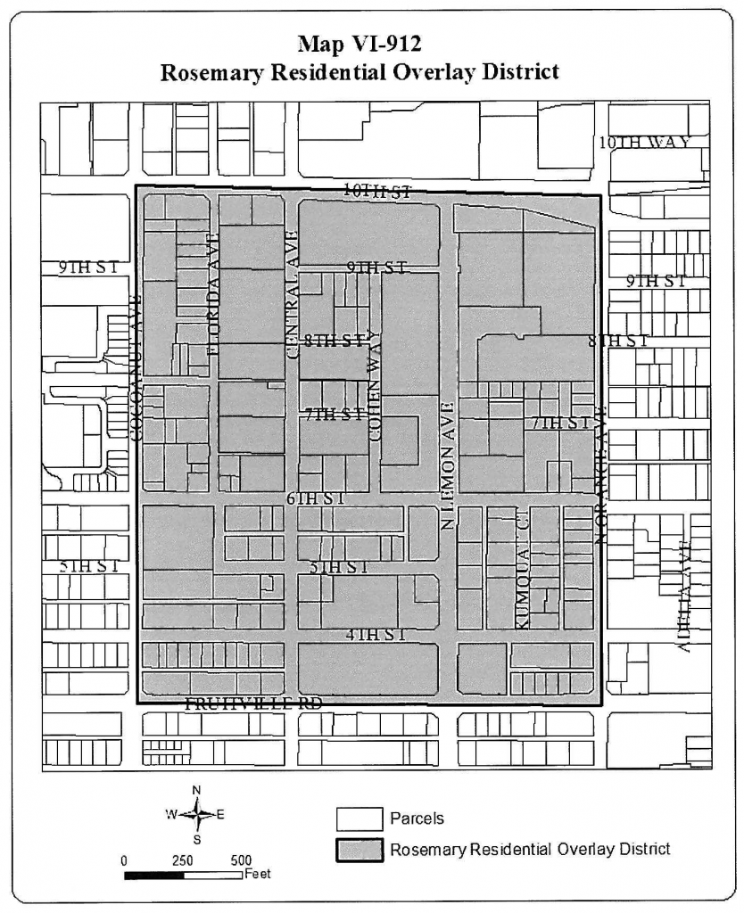
Rosemary Residential Overlay District (RROD).
The Rosemary Residential Overlay District (RROD) and the increased residential dwelling unit density allowable within the overlay district are intended to:
(1) Implement the Sarasota City Plan adopted by Ordinance No. 08-4792, and amended by ordinance.
(2) Promote higher density residential development and use in order to encourage a residential balance to existing nonresidential uses within the RROD. The higher density residential development and use is compatible with existing uses, density and scale of development in the surrounding area. The higher density residential development and use allows for a fully mixed-use area that provides for residential and nonresidential uses in order to create a functional, sustainable, urbanized community within the RROD. This classification provides for and is consistent with the implementation of the Sarasota City Plan.
(3) Encourage more people to permanently reside within the boundaries of the RROD in order to enhance the economic vitality of the Rosemary neighborhood and downtown.
The base density within the RROD is 40 dwelling units per acre. It is the further intent of these regulations that applications for approval of a building permit or site plan for new development (see note 1) with increased density up to 100 dwelling units per acre for new development that comply with certain development standards and when providing dwelling units designated for households with an income at or below 120 percent of the area median income (AMI) in the North Port-Sarasota-Bradenton Metropolitan Statistical Area (MSA) for a minimum period of 30 years, shall be reviewed and approved, approved with conditions, or denied, as appropriate, in accordance with section IV-1901.
(Ord. No. 14-5094, § 3, 10-6-14; Ord. No. 17-5222, § 2, 8-21-17; Ord. No. 19-5284, § 2(Exh. A), 12-2-19; Ord. No. 21-5364, § 2(Exh. A), 5-18-21)
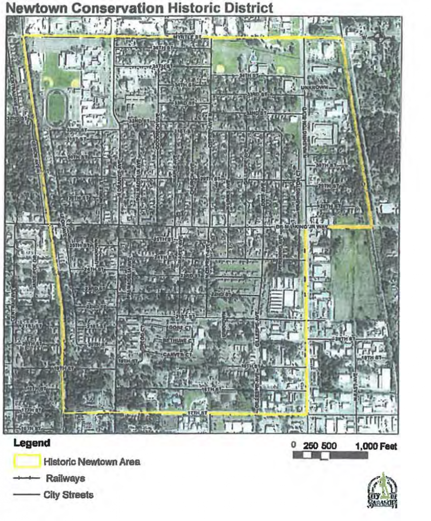
Newtown Conservation Historic Overlay District (NCHD).
The Newtown Conservation Historic District (NCHD) overlay is intended to promote the historic integrity and protect the area from inappropriate demolition, rehabilitation, renovation, uses, alterations, or new development that would be contrary to the existing culture or historic architectural character of the area as identified in the Newtown Conservation Historic District Report.
(Ord. No. 04-4531, § 3, 6-7-04; Ord. No. 04-4573, § 14, 6-20-05; Ord. No. 05-4648, § 3, 1-3-06; Ord. No. 05-4649, § 3, 2-21-06; Ord. No. 05-4650, § 6, 2-21-06; Ord. No. 06-4682, § 2, 7-26-06; Ord. No. 07-4720 § 2, 5-21-07; Ord. No. 07-4770, § 2, 12-17-07; Ord. No. 08-4799, § 2, 4-28-08; Ord. No. 09-4838, § 2(att. 1), 2-17-09; Ord. No. 09-4890, § 2(att. 1), 10-19-09; Ord. No. 10-4912, § 2(att. 1), 6-7-10; Ord. No. 10-4927, § 2(att. 1), 2-22-11; Ord. No. 13-5041, § 2(att. 1), 3-4-13; Ord. No. 13-5055, § 2(Att. 1), 5-6-13; Ord. No. 14-5094, § 5, 10-6-14; Ord. No. 19-5284, § 3(Exh. B), 12-2-19; Ord. No. 20-5309, § 3(Exh. B), 11-3-20; Ord. No. 21-5364, § 2(Exh. A), 5-18-21; Ord. No. 22-5414, § 2(Exh. A), 5-16-22; Ord. No. 22-5430, § 2(Exh. A), 12-5-22; Ord. No. 23-5469, § 2(Exh. A), 4-17-23; Ord. No. 23-5473, § 2(Exh. A), 4-17-23)